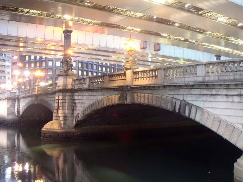
Nihonbashi bridge & the zero-kilometre marker
Nihonbashi has marked the notional centre of Japan since Ieyasu made it the starting point of the Five Routes in 1603, and its bronze zero-kilometre marker still measures every road distance in the country from this spot. The current stone bridge dates to 1911 and has run beneath a Shuto Expressway viaduct, built for the 1964 Olympics, ever since.
Tokyo doesn't really have a downtown, not the way other cities do. It has one patch of ground, a few square kilometres wide, that everybody in charge has wanted for the last four hundred and fifty years, and almost nobody has ever bothered building anywhere else instead. Over the next couple of hours you're going to walk that ground: past the fortifications of the men who once ruled the whole country from behind stone walls, along the moat of the palace that replaced them, through a quarter that briefly answered to a foreign general, and out into streets where all the money eventually landed. Same postcode, four completely different regimes, and barely a metre between any of them. You start today in the old merchants' district, at a bridge that has spent centuries being the point everyone in this city measures distance from. Roughly five kilometres and two hours later, you'll finish somewhere that measures things rather differently, in yen per square metre, at prices that will make the merchants look like they were getting off easy. Let's go see how one small patch of Tokyo kept changing hands without ever changing address.
Look down before you look up. Set into the road surface right here is a small bronze plate, easy to miss under commuter shoes and bicycle tyres. That plate is the Nihon Doro Genten, the zero-kilometre marker of Japan, and it is the single point every road distance in this country is measured from. A stone post nearby lists the mileage to the other major cities — Osaka, Sendai, Nagasaki — and by law every one of those figures starts counting from this exact spot.
Now look up. What you get instead of open sky is the underside of an expressway, six lanes of it, running about thirty feet above the water. This is Nihonbashi, and for more than half a century its defining feature hasn't been the carved stone below or the view along the river, but the concrete slab wedged in between. Woodblock prints from three hundred years ago show a wide-open bridge with Mount Fuji framed beyond it. You will not get that view today. That is the whole point of standing here.
The bridge's importance goes back to 1603, the year Tokugawa Ieyasu made this crossing the starting point of the Five Routes, the Gokaido, the highway network that tied his new capital to the rest of the country. Every daimyo required to travel to Edo under the shogunate's hostage system, every courier, every merchant caravan heading to Kyoto or the northern provinces, began the count of distance from this one plank bridge over a canal. Ieyasu didn't pick the geographic centre of Japan for his zero point — he picked the middle of his own city, and then built the roads to make that true by definition. Two and a half centuries later, when Japan modernised its highway system, nobody moved the marker. They just re-cast it in bronze.
The expressway overhead has its own origin story, and it's a much more recent embarrassment. Tokyo won the 1964 Olympics with about eighteen months' notice to build the infrastructure a host city needed, and elevated highway was the fastest way to add road capacity without buying up the expensive land underneath — so planners ran it straight over the rivers and canals, this one included. It solved a scheduling problem and created a permanent one: one of the city's oldest and most photographed bridges, sealed under a roof of traffic. The fix has been agreed for years now — bury this stretch of expressway in a tunnel, reopen the sky above the bridge — with construction dates that keep sliding further out, currently penciled in past 2040. Don't hold your breath for a good photo.
The bridge itself under your feet is the twentieth version of the crossing, a stone double-arch completed in 1911 after the wooden original burned down and got rebuilt roughly ten times over three centuries. Look at the lamp posts at each end: bronze lions gripping the crest of Tokyo, and above them, winged creatures that the sculptor called kirin — a beast that in Chinese legend has no wings at all. He gave his the wings anyway, on the theory that a city about to become an empire's capital should look like it was ready to fly.
Which is really the question this whole walk keeps circling back to: who owns the middle of Tokyo? Right now, standing on a merchants' bridge with a bank district at your back and a department-store crossing eleven stops from here, the honest answer is commerce — it was commerce in 1603 and, spoiler, it still will be at the very last stop, a shopping crossing not far from where we started. In between, though, the middle of this city gets claimed by a shogun's stone platform, an emperor's moat, and eventually a foreign general with a corner office. Keep that plate under your feet in mind. Everyone who has run this city has had to reckon with it.
Bank of Japan old building
That is stop one, in the walk itself. The remaining 10 stops, the map and the route between them open with one free account.
Continue the walkThe written walk is free.
Thank you! Your report has been submitted.
Report an issue
Help us improve by reporting any issues you notice.