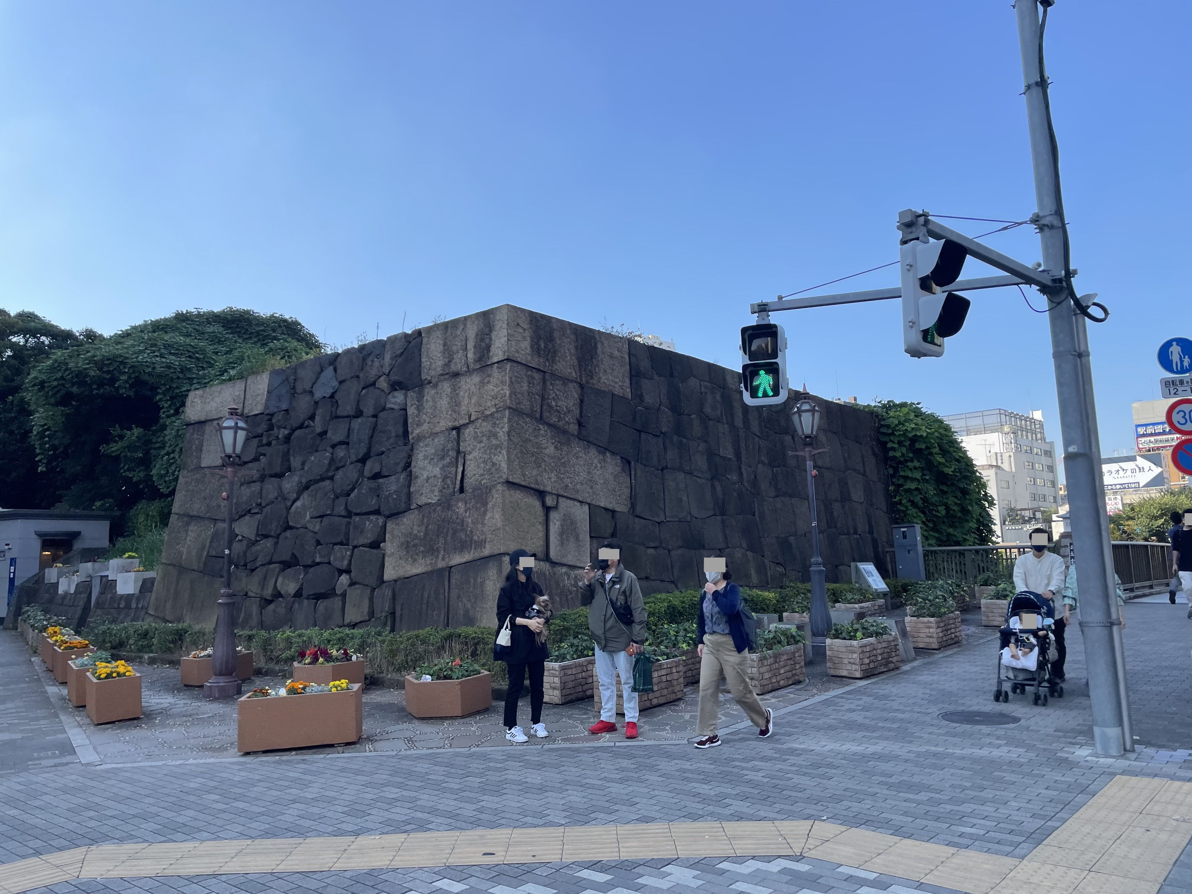
Ushigome-mitsuke Gate Ruins
A pair of masugata stone walls flanking Waseda-dori beside Iidabashi station, all that is left above ground of Ushigome-mitsuke, a gated checkpoint on Edo Castle's outer moat built in 1636 by Hachisuka Tadateru of the Awa-Tokushima domain. The gate was pulled down in 1872 and most of its masonry in 1902; the surviving stonework is part of the nationally designated Edo Castle outer-moat site.
Stand with your back to Iidabashi station's west exit and look across Waseda-dori. A block of old stone sits on each side of the road: squat, weathered, easy to walk past without registering. Those two lumps are why everything else on this walk is here. Nothing you see today is older.
This was Ushigome-mitsuke. Mitsuke is a plain word, from mitsukeru, to spot: a mitsuke was where the guards saw you coming. It marked a point on Edo Castle's outer moat where a road crossed the water, with a gate, a bridge, and a bansho guardhouse just inside for the sentries. Edo is said to have had thirty-six, though that tidy number is really twenty-six proper gates plus ten notable others. The names outlived the gates anyway: Akasaka-mitsuke, Yotsuya-mitsuke, this one.
The clever part was the masugata, the box. You did not walk straight through an Edo gate: you crossed the bridge, passed a first, lower gate, and stood in a walled square courtyard where the second gate, the big one with a tower room over it, sat at ninety degrees to the first. Anyone rushing the castle lost momentum in that turn, and while they turned they were in a stone box with defenders on four sides above. Kagurazaka has another famous dogleg further up this walk; keep this one in mind.
The gate went up in 1636, the last great push on Edo Castle: the shogun Iemitsu called in the daimyo and set roughly a hundred and twenty of them onto the outer moat, some digging, some on the stone. They paid for it themselves, which was rather the point. Ushigome went to the Hachisuka of Awa-Tokushima, on Shikoku, and Hachisuka Tadateru moved men and stone the better part of six hundred kilometres to build a gatehouse he personally had no use for. Masonry and earth bridge were finished that year; towers, doors and guards arrived the next.
Here is the detail I like. Rebuilding the church across the road turned up a stone from the gate's buried footings, cut with the characters Awa-no-kami uchi — of the Lord of Awa's team. A work mark: somebody on the Tokushima gang put their employer's name on a stone designed never to be seen again, and it lay in the dark under this gate for three centuries.
Above ground there is less. The gate came down in 1872, when the new government had no use for checkpoints, and most of the masonry followed in 1902. What survives is this pair, the two flanks of the masugata with a modern road driven between them. Look at the corner nearest you: the long stones alternate, a long face, then a short face, then a long face turned the other way. That is sangi-zumi, the technique that keeps a corner from shearing away. The outer-moat remains became a national historic site in 1956.
Now turn to the water. This moat was not dug from nothing: the engineers widened an existing stream valley, which is why it is broad here where elsewhere it is a ditch. The railway you walked out of was laid into the moat's own space in 1894, at a station then called Ushigome, and the embankment above it is a park today. The moat's other survivor, a boathouse, is our next stop.
Then the road. Out of this gate the highway ran west and uphill, toward Kagurazaka, Takadanobaba and Itabashi. A guarded gate plus a road produces traffic; traffic produces temples, lodgings and teahouses; and a century and a half later a temple settled on the crest of that slope and a trade grew at its gate. The order matters, and it is this walk's argument. The hill was not laid out for what it became. It was laid out for this gate, and everyone since has been a tenant.
Even the name is a hand-me-down. Ushigome is usually explained as "cattle enclosure", from imperial pasture granted in Musashi province as early as the eighth century. The warrior family who later held this hill did not name it. They came from elsewhere, took the place's name as their own, and this walk ends at the shrine they brought with them.
Practically: ten stops, a little over two kilometres, about ninety minutes, ending at Kagurazaka station. The walk itself is free — the only money you might spend is on a coffee, a bathhouse or a boat, and all three are optional. Call it moderate rather than easy: a sustained climb up the main slope, then twenty-two uneven stone steps at one stop and more at another. Wear shoes for them. And if you can, time the walk to reach the fourth stop near noon. The main street does something at twelve o'clock worth standing still for.
Canal Cafe (Tokyo Suijo Club)
That is stop one, in the walk itself. The remaining 9 stops, the map and the route between them open with one free account.
Continue the walkThe written walk is free.
Thank you! Your report has been submitted.
Report an issue
Help us improve by reporting any issues you notice.